CASPER
New member
How To Use Dishpointer.Com
I just wanted to do a quick Tutorial on how to use dishpointer.com, since alot of the questions in chat are about dish aiming.
First, go to Satellite Finder / Dish Pointing Calculator with Google Maps | DishPointer.com.
(DO NOT USE ANY OF THE VALUES THAT ARE HERE. THIS ADDRESS IS JUST AN EXAMPLE. USE THE VALUES FROM YOUR OWN ADDRESS. THIS IS JUST TO SHOW YOU WHAT YOU NEED TO HAVE AS FAR AS VALUES. (ELEVATION, SKEW, IF YOU NEED IT, AZIMUTH AND LATITUDE AND LONGITUDE). SO YOU WILL KNOW WHERE THEY ARE LOCATED ON THE SITE)
Once you get there, you'll see a spot to enter your address. Enter your complete address including zip code in the box. It should look like this:
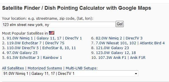
Once this is done, click GO!.....You'll see some of the more popular satellites under your address...click on the one you want to aim at...you'll see the coordinates below the map change for each sat.
In this pic, I chose 119.0W.
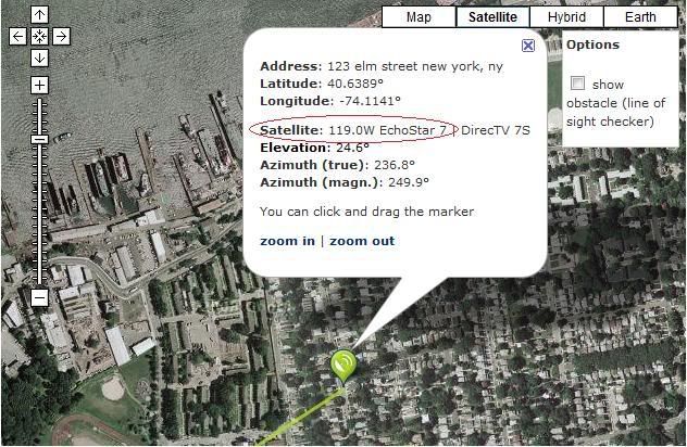
And here comes the tricky part...below the map, you'll see some numbers...
These are what your looking for.
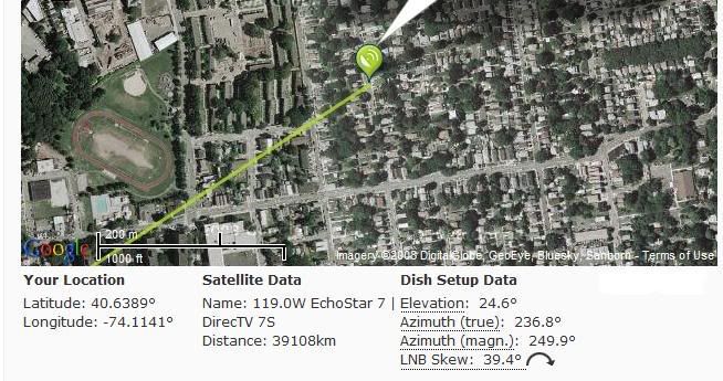
If your Dish has a single LNB (one eyeball) then pick the sat you want and get the coordinates for it...Azimuth (left, right) would be 1, and Elevation (up, down) would be the other.
If your using a DP Twin LNB or DPP Twin (2 eyeballs encased in 1 plastic frame) then you can choose 2 sats (that are 9 degrees apart)..Like 110.0W and 119.0W...In this case the other number that you would need is skew..This is the skewing (turning) of the dish to get in both sats.
Once you set your Elevation and Skew the rest is just left, right turning (Azimuth) to find your signal.
Then of course your minor tweaks to get the best quality you can...And remember peeps, these numbers are not written in stone...you may need to adjust the elevation a little higher or lower.
But all of us have done this one time or another, and found what we were looking for...
Also, I'd like to leave you with another tip...when you get in a signal and you have decent quality, and you want to see if you can get better quality, do not loosen any bolts on the dish...just grip the sides of the dish and "flex" it left and right...very little...If your going to get better quality, you'll see it with just a minor "flex"...if you don't see a change in quality by doing that, then try gripping the top of the dish with one hand, and the bottom with the other and "flex" up a little...and then down a little...remember, your not trying to bend the dish, just very little "flexing"...if you do start to see a change in quality, then loosen the bolts just a little and move the dish very slightly in the direction you noticed the quality was getting better...then tighten the bolts back up...If you follow these steps, you'll be aimed and watching tv in no time...
Also, on another note...Alot of users aren't sure where the satellites are in the sky...
When you look at the numbers below the map, you'll see latitude and Longitude there...These are very important numbers...Your Longitude tells you where you lie on the earth going from North to south...Your Latitude tell you where from East to West...
The Reason these are important, are:
If you look at your Longitude, you'll know how far away you are from any sat in the sky.
These sats are not just thrown up there...the numbers on these sats (82.0W, 91.0W, 110.0W, 119.0W)
These numbers tell you what Longitude the sats lie at...I think I seen a few light bulbs go on there...lol
Starting to see the picture yet?
For instance, if you live in the USA , let's say Florida...
On the Eastern Horizon, would be (I'll use Echostar & BEV for the example) 61.5W...then 82.0W then 91.0W, then 110.0W, then 119.0W and finally 129.0W....see how they go in order from lowest (61.5 Longitude) to highest (129.0W Longitude)...Now, if you live at 78 degrees Longitude, then you know that from where you are (78 degrees longitude) to 91.0W is 13 degrees to the right...Thats why knowing Longitude is important..Also, it's important to know that the satellites are in an Arc over the Equator...(like a rainbow, with 61.5W at the bottom left side of the rainbow and 129.0W at the bottom right side of the rainbow...and you'll see how elevation plays in there...that would make 82.0W or 91.0W highest in the arc (rainbow)..
Well, I didn't want this to be a lesson in astrophysics...lol..But if I keep going on, it will be...
Hope this helps you guys..
I just wanted to do a quick Tutorial on how to use dishpointer.com, since alot of the questions in chat are about dish aiming.
First, go to Satellite Finder / Dish Pointing Calculator with Google Maps | DishPointer.com.
(DO NOT USE ANY OF THE VALUES THAT ARE HERE. THIS ADDRESS IS JUST AN EXAMPLE. USE THE VALUES FROM YOUR OWN ADDRESS. THIS IS JUST TO SHOW YOU WHAT YOU NEED TO HAVE AS FAR AS VALUES. (ELEVATION, SKEW, IF YOU NEED IT, AZIMUTH AND LATITUDE AND LONGITUDE). SO YOU WILL KNOW WHERE THEY ARE LOCATED ON THE SITE)
Once you get there, you'll see a spot to enter your address. Enter your complete address including zip code in the box. It should look like this:
Once this is done, click GO!.....You'll see some of the more popular satellites under your address...click on the one you want to aim at...you'll see the coordinates below the map change for each sat.
In this pic, I chose 119.0W.
And here comes the tricky part...below the map, you'll see some numbers...
These are what your looking for.
If your Dish has a single LNB (one eyeball) then pick the sat you want and get the coordinates for it...Azimuth (left, right) would be 1, and Elevation (up, down) would be the other.
If your using a DP Twin LNB or DPP Twin (2 eyeballs encased in 1 plastic frame) then you can choose 2 sats (that are 9 degrees apart)..Like 110.0W and 119.0W...In this case the other number that you would need is skew..This is the skewing (turning) of the dish to get in both sats.
Once you set your Elevation and Skew the rest is just left, right turning (Azimuth) to find your signal.
Then of course your minor tweaks to get the best quality you can...And remember peeps, these numbers are not written in stone...you may need to adjust the elevation a little higher or lower.
But all of us have done this one time or another, and found what we were looking for...
Also, I'd like to leave you with another tip...when you get in a signal and you have decent quality, and you want to see if you can get better quality, do not loosen any bolts on the dish...just grip the sides of the dish and "flex" it left and right...very little...If your going to get better quality, you'll see it with just a minor "flex"...if you don't see a change in quality by doing that, then try gripping the top of the dish with one hand, and the bottom with the other and "flex" up a little...and then down a little...remember, your not trying to bend the dish, just very little "flexing"...if you do start to see a change in quality, then loosen the bolts just a little and move the dish very slightly in the direction you noticed the quality was getting better...then tighten the bolts back up...If you follow these steps, you'll be aimed and watching tv in no time...
Also, on another note...Alot of users aren't sure where the satellites are in the sky...
When you look at the numbers below the map, you'll see latitude and Longitude there...These are very important numbers...Your Longitude tells you where you lie on the earth going from North to south...Your Latitude tell you where from East to West...
The Reason these are important, are:
If you look at your Longitude, you'll know how far away you are from any sat in the sky.
These sats are not just thrown up there...the numbers on these sats (82.0W, 91.0W, 110.0W, 119.0W)
These numbers tell you what Longitude the sats lie at...I think I seen a few light bulbs go on there...lol
Starting to see the picture yet?
For instance, if you live in the USA , let's say Florida...
On the Eastern Horizon, would be (I'll use Echostar & BEV for the example) 61.5W...then 82.0W then 91.0W, then 110.0W, then 119.0W and finally 129.0W....see how they go in order from lowest (61.5 Longitude) to highest (129.0W Longitude)...Now, if you live at 78 degrees Longitude, then you know that from where you are (78 degrees longitude) to 91.0W is 13 degrees to the right...Thats why knowing Longitude is important..Also, it's important to know that the satellites are in an Arc over the Equator...(like a rainbow, with 61.5W at the bottom left side of the rainbow and 129.0W at the bottom right side of the rainbow...and you'll see how elevation plays in there...that would make 82.0W or 91.0W highest in the arc (rainbow)..
Well, I didn't want this to be a lesson in astrophysics...lol..But if I keep going on, it will be...
Hope this helps you guys..